
10 Hiking Trails Across The US That Are Both Wildly Scenic And Boomer-Friendly

"Baby Boomers" is the generational term broadly used for those born roughly between 1946 and 1964. This generation may not be as young as it once was, but Boomers remain one of the most traveled generations in the U.S. today. Many still lace up their boots and hit the Himalayas or take on the Swiss Alps; trips like these are hard to give up. But for others, the knees aren't what they used to be, and the lungs take longer to recover. But that doesn't mean wild scenery is out of reach now. It just means a change of approach might be necessary.
The United States is home to some of the planet's greatest hiking trails. But many of these trails are demanding, and many people, particularly Boomers, might not want to push themselves too hard. But here's the thing: You don't have to. To find suitable trails in the U.S. for people of a certain age, we consulted authoritative sources like Outside Online, AARP, Road Scholar, the Wilderness Society, and Sunset Magazine. We then cross-referenced our findings on AllTrails and National Park Service guides.
Our selections were chosen for scenic beauty, accessibility, and suitability for older hikers. Diversity in terrain, landscape, and geography was also accounted for. We've included things like coastal paths beside crashing surf, boardwalks through wetlands alive with wildlife, old-growth rainforest in the Pacific Northwest, and alpine lakes reflecting stunning peaks. These landscapes are every bit as dramatic as the big-ticket trails — and far more accessible than you might expect. Here are 10 wildly scenic and boomer-friendly hiking trails across the U.S.
Ocean Path Trail, Acadia National Park, Maine
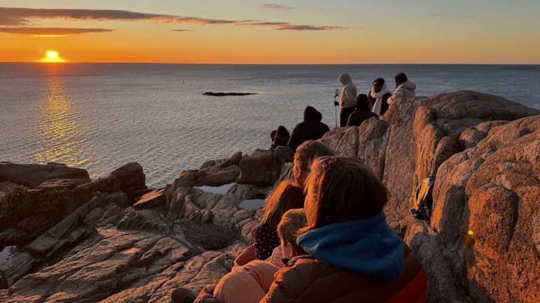
You can experience plenty of postcard-worthy scenery when exploring Acadia National Park. But the ocean is never far for the entire length of the Ocean Path Trail. It's 2.2 miles one way along Maine's most dramatic coastline, and there's no significant climb. The walk takes just two to four hours at a relaxed pace, and the path is well maintained. You'll see pink granite shelves dropping straight down into the Atlantic the moment you set out from Sand Beach. Then, about three-quarters of a mile in, you'll discover Thunder Hole. This narrow slot in the cliffs forces ocean swell into the rock below. If it's high tide and the wind is behind, you'll easily hear it long before you see it.
Beyond Thunder Hole, the path gets a bit uneven and has granite stairs to navigate, but it can still be manageable. It takes you to the highlight of the trail — Otter Cliffs. Rising 110 feet out of the sea, these sheer faces of rust-colored granite are the tallest coastal cliffs on the eastern seaboard. Many decide to head back at this point, and should you choose to do so, you won't be shortchanged.
You'll have already seen the trail's most dramatic scenery. However, you might decide to press on to Otter Point. This is where the granite pushes out into the ocean on either side of a peninsula with views of wave-battered sea stacks and the open ocean. You can catch the free Island Explorer Shuttle Bus from there back to Sand Beach. If you decide to turn back at Otter Cliffs, you can flag it down from the road.
Anhinga Trail, Everglades National Park, Florida

The Anhinga Trail is not only the most accessible window into Everglades National Park, but it's also one of the most scenic trails in all of Florida. At under a mile with no elevation gain and a paved or boardwalk surface the whole way, it's a walk almost anyone can manage. The trail is one of the best hiking trails in America for wheelchair users, and Taylor Slough runs alongside it through the marsh. This dark and still wetland channel holds water year-round, even when the rest of the park is bone dry. That's why wildlife congregate here in such numbers, and that's what most people come to see.
Alligators bask in the sun as still as statues everywhere here. They have no interest in moving for you, and many first-time visitors sometimes ask if they are actually real. You'll also see the anhinga, the bird the trail is named for, driving its beak through fish like a spear, while egrets and herons wade in the shallows. Cormorants cluster in the trees, too, and in spring, the branches fill with nesting roseate spoonbills.
Since most animals are more active before the heat of the day kicks in, arriving early is preferable. Before 9 a.m is best, not only for this but also to grab a parking spot. The lot fills up fast during peak hours. After 4 p.m., however, golden hour colors are at their most vibrant, and the crowds have mostly gone home. You'll need bug spray at any time of day, and if you visit during peak hours, bring high-factor sunscreen, a hat, and more water than you think you'll need. There is little shade.
Hall of Mosses Trail, Hoh Rain Forest, Olympic National Park, Washington
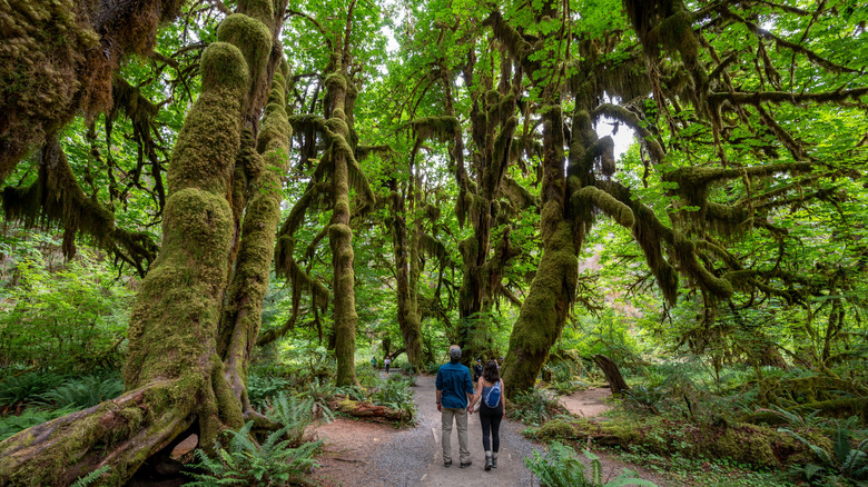
The rainforests in the Pacific Northwest are considered among the richest moss ecosystems on the planet. The Hoh Rainforest is one such. It's an ethereal Washington gem with lush views beyond belief deep inside Olympic National Park. Right at its visitor center, you'll find one of the lushest, most otherworldly trails in the U.S. The Hall of Mosses Trail is mostly accessible to all, with the first stretch gently graded and easy underfoot. However, the path rolls over steeper sections further in that are unsuitable for wheelchairs. Still, the 100-foot elevation gain is manageable for most, and the 0.8-mile loop takes around an hour and a half at a leisurely pace.
The signature sight on the trail is a grove of bigleaf maples that are draped so heavily in moss they seem to be wearing it like baggy robes. The thick, hanging curtains of green drip from every surface from the ground up and turn the forest into something from the realms of fantasy. The old growth also harbors Sitka spruce, red cedar, Douglas fir, and western hemlock, some of which soar up to 250 feet.
Around 500 Roosevelt Elk roam the Hoh River Valley, and catching sight of them near the trail is a possibility. Stay quiet and watch from a distance if you spot any. Your best chance of seeing any wildlife is early in the day. It's also the best time to beat the crowds, but after 4 p.m. works as well. But whenever you visit, bring a rain jacket and waterproof footwear. This is one of the wettest places in the continental U.S. Spring can bring particularly treacherous mud after heavy rain, so summer and fall are the most comfortable times.
Zion Narrows Riverside Walk, Zion National Park, Utah
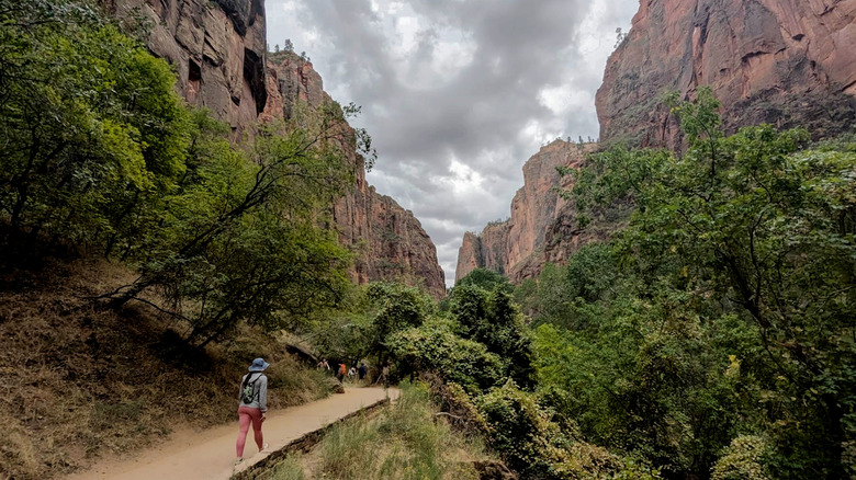
The Narrows is the most famous hike in Zion National Park. It's quite simply an enchanting adventure through nature's beauty. But to experience it, you must journey through a slot canyon and wade along a rocky riverbed with water rising up to your waist. It's not for everyone. But that doesn't mean anyone who feels they can't do it has to miss out on the incredible scenery. The Riverside Walk is a flat, paved trail that leads into Zion Canyon, where you'll find the start of the Narrows. It's a 2.1-mile round-trip to get there, fully wheelchair-accessible, and manageable for all ages and fitness levels.
The deeper you walk along the trail into Zion Canyon, the taller the sandstone walls rise on every side. Rust-red and streaked with desert varnish, they press in closer and closer until the sky above narrows to a ribbon of blue. Ferns, moss, and trees sprout from the walls wherever water seeps through the rock, forming hanging gardens of vivid green against the red sandstone. It's a great place for wildlife spotting, too. Mule deer are common, especially when the sun is setting. Blue herons also fish here, while wild turkeys are a regular sight.
You can reach the trailhead by the Zion Canyon Shuttle, which runs from mid-February through late November. Personal vehicles are restricted to those who need them during the shuttle season. If you have a qualifying medical need, you can obtain a permit at the visitor center. But always check weather conditions first; while the Riverside Walk is not subject to flash floods like the Narrows, the trail can be closed during storms or periods of high water.
Congress Trail, Sequoia National Park, California
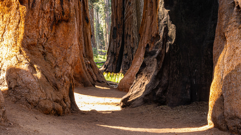
You'll find North America's largest tree nestled in Sequoia National Park. It's called General Sherman, and it stands at 274.9 feet at the beginning of the Congress Trail. It is, in fact, the largest tree on the entire planet by volume, but there are many more giants to see on the Congress Trail. It's a fully paved route that takes you through what is the densest concentration of large sequoias in the park, but most visitors don't walk it. This means it's blissfully quiet. Throughout the hike, you'll discover trees named after American presidents, like McKinley, Lincoln, and Washington. They have been there a very long time, too. The General Sherman is thought to be anywhere between 2,300 and 2,700 years old, but sequoias can live to well over 3,000 years.
The hike itself is a fairly easy 2.7-mile lollipop trail. You can do it at a comfortable pace in an hour to an hour and a half. Some less mobile hikers may want to turn back at the 0.6-mile mark. Beyond there, the trail starts to go up and down in sections that can be steep enough to challenge some. Coming in, wheelchair users should park at the accessible lot on Generals Highway, where a paved, mostly flat trail leads directly to the Sherman Tree. The main parking lot is a 200-foot downhill descent. On your return, the free park shuttle stops at the Sherman every 15 minutes or so in summer, which means you can avoid the uphill walk back to the parking lot.
Lower Yosemite Falls Trail, Yosemite National Park, California
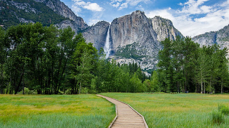
Many of Yosemite's iconic views require serious hiking. In fact, some of the park's hikes are downright dangerous. The Lower Yosemite Falls Trail isn't one of them. Choosing it means a flat, paved one-mile loop with only 50 feet of elevation gain. And you can do it in under an hour. You'll catch sight of all three waterfall sections. There are multiple vantage points offering views of the Upper and Lower Falls, as well as the Middle Cascade.
You'll eventually wind up at Lower Yosemite Falls, the final 320-foot plunge of Yosemite Falls, one of the tallest on Earth. In spring and early summer, the water hits the valley floor in a thunderous roar that you can feel in your chest. Stand at the footbridge's base, and you'll get a refreshing soak from the spray. Rocks above the footbridge can be treacherous underfoot, and there have been injuries on the trail resulting from off-trail scrambling, so stick to the path.
Even on the path, you can get icy patches developing in winter, and by late July or August, the falls run dry and don't return until October. When it's not icy, the eastern part of the loop is wheelchair accessible. It will take you all the way to the footbridge, but you'll then need to turn back rather than following the entire loop. To get to the trailhead and back, you can take the free Valleywide Visitor Shuttle, which stops nearby.
Bear Lake Trail, Rocky Mountain National Park, Colorado
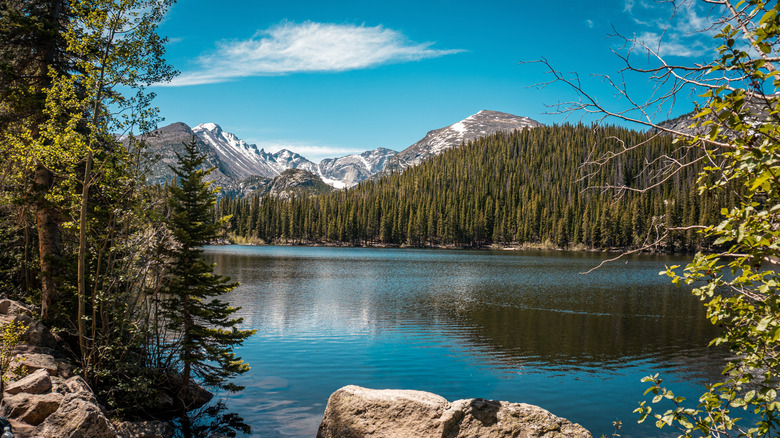
Bear Lake was gouged out by a retreating glacier thousands of years ago and sits at an elevation of 9,468 feet. It's a deep blue pool enclosed by forest and rock, with snow-capped peaks pressing in from every side. This is genuine high-alpine scenery, and anywhere else in the Rockies, this kind of view would cost you a serious climb. However, the half-mile loop around the lake is, in fact, a flat, accessible-to-all stroll that you can do in 30 minutes to an hour at a comfortable pace.
From the east side of the lake, Hallett Peak dominates the view. From the north, Longs Peak comes into sight with the Continental Divide stretching across the skyline behind on a clear day. On the far side, the crowds start to thin out, and there are plenty of benches dotted around where you can sit, relax, and take in the stunning landscapes. You can even join the Nymph Lake trail to extend the hike and enjoy one of the world's most beautiful hikes even more.
The trail is open year-round, but in the peak summer season, there is a free Rocky Mountain shuttle that'll take you to the trailhead. Arrive between 7 and 8 a.m. to get ahead of the pack, and remember, those sunny afternoons at altitude mean you should apply plenty of sunscreen and bring a hat. Summer can also bring fast-moving thunderstorms, so check the forecast before heading out. Come fall, the summer crowds have largely gone, and the aspens are burning gold, but snow can arrive anytime from late October through May. At this time, snowshoes or microspikes are not optional.
Max Patch Loop Trail, Pisgah National Forest, North Carolina
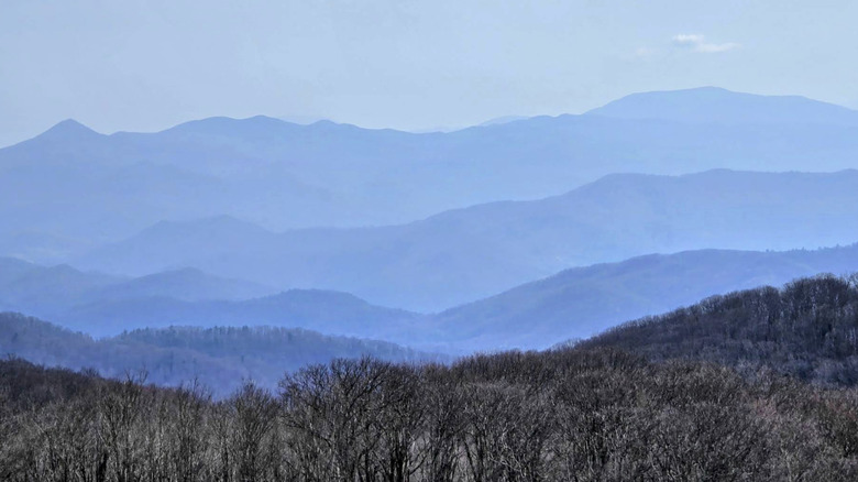
The Appalachian Trail runs 2,197.9 miles from Georgia to Maine. At one point, it crosses a treeless grass dome at 4,600 feet. Max Patch is where thru-hikers stop, drop their packs (and their jaws), and just stand and admire the 360-degree panorama. Mount Mitchell rises dramatically to the northeast, the Great Smoky Mountains mass to the southwest, and ridge after ridge of the Appalachians roll away in every direction. However, you don't need to be hiking the Appalachian Trail to see these views. You can reach the same spot in three-quarters of a mile from the Max Patch trailhead parking lot in the Pisgah National Forest. With 311 feet of elevation gain, the 1.5-mile Max Patch Loop Trail is rated easy, and it will probably take around 30 minutes to an hour to complete.
Nobody can fully agree on why mountain balds exist. What's certain is that without a single tree to interrupt them, the views are complete. The open summit makes Max Patch one of the better places in the southern Appalachians to watch the sun rise or set. The sky is unobstructed, and the light hits the ridges from every angle. In fall, the surrounding forest turns, with September and October bringing the best color. However, with no tree cover, you should avoid the summit in thunderstorms and slap on the sunscreen when the sun is beating. In winter, the access road can close due to snow and ice.
Maroon Bells Scenic Loop Trail, Aspen, Colorado
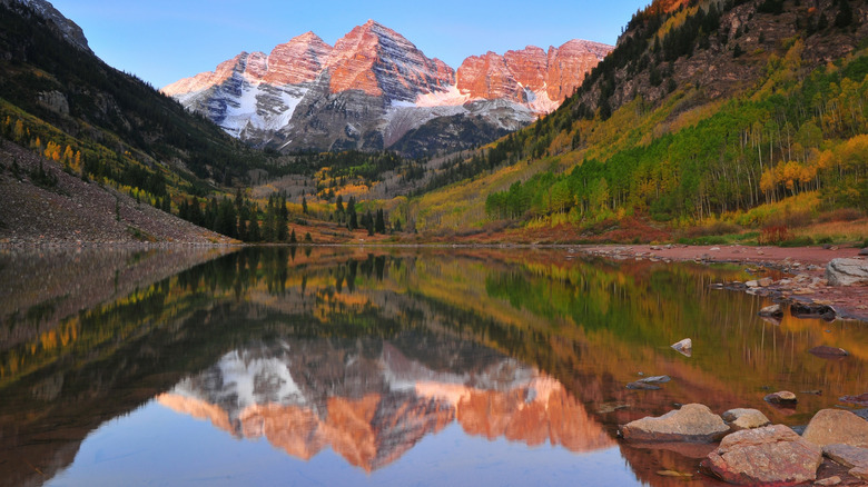
The Maroon Bells are the most photographed place in Colorado. And the Maroon Bells Scenic Loop Trail puts you right in front of the most photogenic spot. Rising above Maroon Lake are the two Bells, the Maroon and North Maroon Peaks. Their rust-colored faces drop straight back down into the still lake to form a perfectly symmetrical, unbroken image. It's quite the sight, and it doesn't require too much effort to get to.
The trailhead sits within the Maroon Bells-Snowmass Wilderness, about 11 miles outside of Aspen. A daily bus connects the city to the Maroon Bells Recreation Area in around 20 minutes. This might be a sensible option on weekends and peak season, as the parking lot can get particularly busy. The area is only open from May through October, and 300,000 visitors descend on it during this time. So it's pretty busy, and getting there first thing makes a difference.
The loop itself is 1.9 miles long with just 161 feet of elevation gain. It'll take around an hour to complete, and the trail is well-maintained. But it is a dirt trail, so you'll need some decent footwear. However, it is the kind of walk you can do slowly. There's no good reason to hurry, and you'll likely stop often to take photos. The grandkids will love to watch the beavers industriously maintaining their dam along the way before you cross a bridge over West Maroon Creek. Here, rapids churn white through the rocks below. Then, after that, you arrive at that stunning lake reflection.
Upper Geyser Basin Trail, Yellowstone National Park, Wyoming
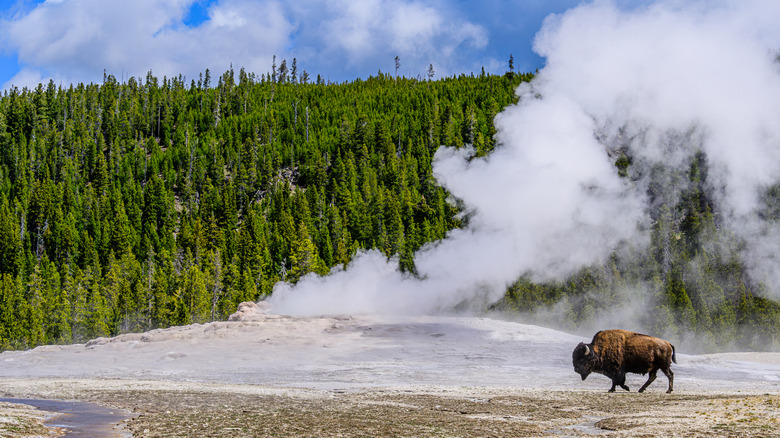
The Upper Geyser Basin in Yellowstone National Park is the place to go for geothermal wonders. It's home to more geysers than anywhere else on Earth. You've probably heard of Old Faithful — but it's just the opening act. The Old Faithful Inn marks the trailhead, and it's absolutely worth checking this out before your hike. It's the largest log structure in the world, and inside, you'll discover a soaring interior of balconied galleries and a huge stone fireplace rising through the center. Back outside. Old Faithful erupts every 44 minutes to two hours. It shoots scalding hot water up to 180 feet into the air. You can see it safely from viewing benches, then follow the boardwalk into the basin for over 200 more geothermal features.
There are more geysers, including the Grand Geyser, which dwarfs all the others. You'll also see the Morning Glory Pool. It sits near the far end of the loop and is a hot spring ringed in vivid orange and yellow, giving way to bright green and a deep blue-green core. These alien colors are the work of thermophilic bacteria that thrive in water that is close to the boiling point. You'll also see fumaroles venting steam into the cool air, while bison wander the scene unbothered. It's a thrilling-yet-easy, 3.2-mile loop of boardwalk and paved path with barely any elevation gain. You can do it in an hour and a half, or you can take as long as you like, although early morning and dusk give the best chance of quieter trails and unobstructed views.