9 Easy Scenic Drives Across The US You Should Do At Least Once
Driving the most scenic routes in the United States is a celebration of the country's urban centers and showstopping landscapes. If you're not just trying to get from A to B, these picturesque routes absolutely do not need to be rushed. Instead, you can traverse them at a leisurely pace and plant yourself firmly in America's legendary terrain, either on iconic highways or obscure backroads. There are dense forests of ancient trees yielding to vast, yawning canyons, while endless plains transition into dramatic coastline. It doesn't matter if you crave wind-in-your-hair freedom or incredible scenic corridors; road-tripping in America delivers stunning scenery and adventure.
Just about every mile of road in the United States is an opportunity for discovery. Sticking to scenic byways and secondary routes can offer more nature, superior vantage points, and, perhaps best of all, lighter traffic at a deliberately relaxed tempo. Spontaneous detours and stops along these routes can lead to discovering quirky little towns or offbeat roadside attractions — and likely more authentic cuisine and warm, friendly locals, too.
If you're not in a hurry, you can conquer thousands of miles by transforming daunting distances across states into easy-to-drive sections. You can plan for regular rest breaks, sightseeing, and overnight stops to eliminate fatigue and combat stress, as every leg of your journey should deliver fun times, even when tackling America's longest highways. From 70 to over 3,000 miles, here is a selection of scenic drives that are easy, or at least customizable enough that you can make them easy.
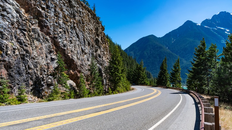
Blue Ridge Parkway
The Blue Ridge Parkway is a 469-mile stretch of asphalt through the Appalachian Mountains that is considered by many to be America's favorite drive. It's a route that favors gentle, gradual curves, and the speed limit is capped at a leisurely 45 mph. If you're determined to make it a day trip, you can traverse the entire route in about 10 hours. But with so much to see, why would you want to do that?
The parkway links Shenandoah National Park in Virginia to the Great Smoky Mountains National Park in North Carolina and winds its way across a landscape deliberately devoid of commercial development. So, while the drive is scenic and manageable, there are few amenities. However, you will find eight campgrounds dotted along the parkway that operate on a first-come, first-served basis. It should be noted that they don't provide hookups, and they will be much quieter on weekdays.
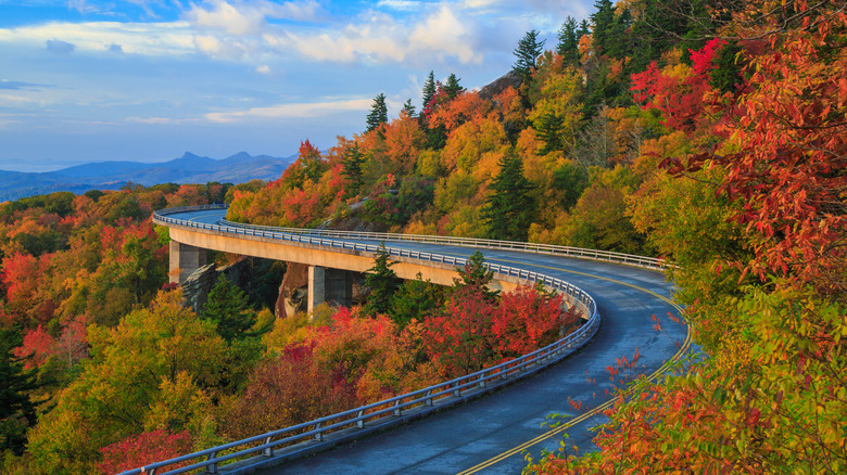
Points of interest along this route include the Linn Cove Viaduct, a triumph of engineering that curves gracefully around the sheer face of Grandfather Mountain and is the parkway's most photographed structure. Then there's the three-tiered Linville Falls, which cascade down dramatic rocky cliffs into the precipitous Linville Gorge, earning itself the nickname "Grand Canyon of the Southern Appalachians." Another unmissable sight is the highest peak in the Eastern U.S., Mount Mitchell. You can turn off at mile 355.4 and drive almost to the summit — and if you visit in the fall, you'll be treated to hillsides bursting with crimson, gold, and orange foliage.
Pacific Coast Highway
Spanning 1,650 miles from Port Townsend near Olympic National Park in Washington almost all the way to the Mexican border, the Pacific Coast Highway is nothing short of epic. Driving the entire route is a big commitment, so most travelers make it easy by driving specific segments. Popular sections include San Diego or Los Angeles to San Francisco, and the Oregon and Washington coastal stretches.
Whichever route you take, ocean views and stunning scenery will accompany you for almost the entire journey, with southbound drivers having the distinct advantage of occupying the ocean-side lane. It's predominantly a two-lane route that traverses dramatically shifting ecosystems from snowy peaks to lush temperate rainforest to almost desert-like conditions. Drivers should note that while there is an abundance of amenities most of the way, they can thin out in remote stretches, so plan fuel stops accordingly.
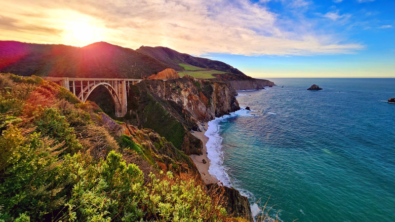
In Northern California, you'll be treated to stunning sites like the Redwood National Park and the Avenue of the Giants with their towering redwood groves. Further south, Big Sur is undoubtedly the highlight, but it's also one of the more challenging sections. Try to keep your eyes on the serpentine road there, and don't get too distracted by the rugged cliffs plunging down into the blue waters of rocky outcrops dotted along the coastline. You'll also cross the Bixby Bridge here, one of the most famous landmarks on the route. In fact, there are so many stunning stops on the Pacific Coast Highway that you could end up spending weeks trying to cram them all in.
U.S. Route 66
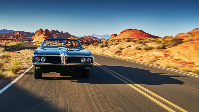
The "Mother Road" isn't just America's most iconic highway and a must-do road trip; it's a world-famous cultural phenomenon. Route 66 has captured global imaginations thanks to its immortalization across the media, with its most notable celebration perhaps being 1969's classic counterculture movie "Easy Rider." Fans of the film will recognize iconic sites, such as the breathtaking scenery around Monument Valley and the Pine Breeze Motel in Bellemont, Arizona, where Billy and Wyatt were denied a room for the night. The ghost town of Ballarat in California — where Wyatt throws his Rolex away — is also at the top of fans' bucket lists, among many other locations along this legendary road.
Route 66 stretches for almost 2,500 miles from Chicago to California and passes through no less than eight U.S. states. Upon its full paving in 1938 after 11 years of construction, it became the most direct connection between the Midwest and the Pacific Coast, and driving it involves long stretches of smooth, open road, but prepare for some hills and high-altitude desert along the way. However, given its length, you might want to break the drive into manageable sections to make it easier or just explore the parts you really want to see.
Wherever you venture, this nostalgic route takes in small-town communities, eccentric roadside attractions, classic diners, family-owned motels, and quirky gift shops that maintain an authentic mid-century American road-trip atmosphere. There are also, of course, unmissable landmarks like the Grand Canyon National Park and the Petrified Forest National Park to marvel at along the way, too.
Great River Road
All-American roads must possess significant attributes that set them apart from being a mere National Scenic Byway. Basically, they must be considered a destination in themselves, possessing characteristics that make one simply want to drive them, and the Great River Road definitely fits the bill. It's a scenic route that crosses 10 states, following the mighty Mississippi River on an incredible 3,000-mile journey from northern Minnesota to the warm waters of the Gulf of Mexico. It might be 50% longer than the equivalent interstate route, but then you're not driving it to get anywhere fast. It's a road that was simply built for scenic driving, deliberately meandering through countless communities and continuously crisscrossing the world's fourth-longest river.
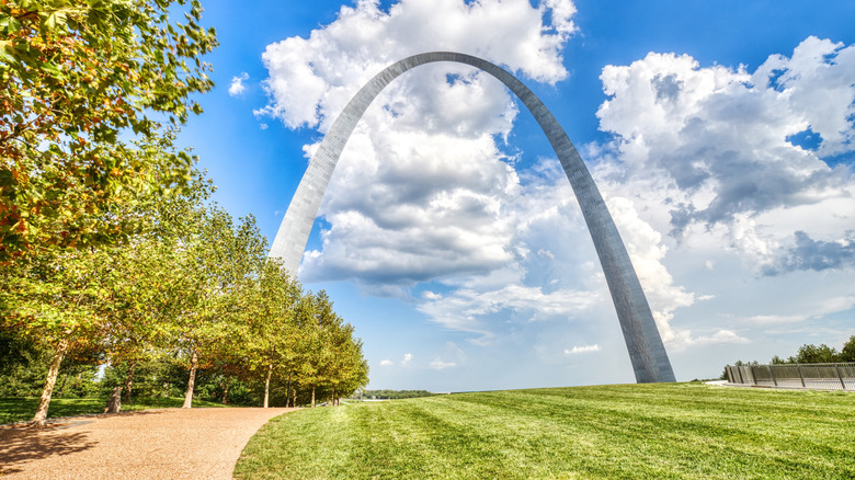
You can conquer the entire route in a day and a half if the coffee and your will are strong, but most travelers will take around two weeks and take in all the sights at a leisurely pace. You'll pass various landscapes, including upland meadows, murky cypress swamps, dense hardwood forests, and towering limestone cliffs. Then there are the numerous protected parks and wildlife sanctuaries, with notable stops including Minnesota's Lake Itasca State Park, where the Mississippi begins its continental journey. You'll also discover the Native American burial and ceremonial site, Effigy Mounds National Monument in Marquette; the Gateway Arch National Park in St. Louis; the historic French Quarter in New Orleans; and the unmissable Graceland, home of the King of Rock and Roll, in Memphis.
Overseas Highway
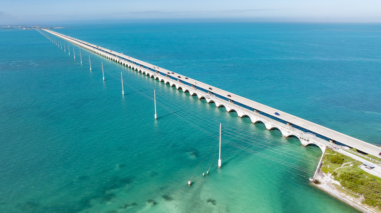
The impossibly scenic Overseas Highway has earned the rather fitting nickname "the Highway That Goes to the Sea" — because it literally does. It's a drive to a tropical paradise, extending for 113 miles from Key Largo to Key West in Florida, and is the state's one and only All-American Road. The trip involves crossing 42 bridges that form the highway's structural backbone across the Atlantic Ocean, Florida Bay, and the Gulf Coast. You can start the journey with a visit to the John Pennekamp Coral Reef State Park, the first protected underwater area in the country. It covers 70 nautical square miles and is an excellent stop for glass-bottom boat tours, scuba diving, snorkeling, and kayaking.
If you're a keen angler, visiting Islamorada is a must. It's known as the "Sport Fishing Capital of the World," and it is where you'll discover the Florida Keys' most extensive armada of deep-sea charter vessels and shallow-draft backcountry fishing boats. Other key attractions include the Turtle Hospital in Marathon (a rehabilitation center for injured sea turtles) and the Seven Mile Bridge, which stretches across brilliant turquoise water in the direction of Bahia Honda State Park, where you can take in scenic views from its historic railroad bridge.
The highway terminates at Mile Marker 0 in Key West, mainland America's southernmost municipality. This is where you'll find 19th-century architectural gems standing alongside historic landmarks like Ernest Hemingway's 1930s residence and Harry Truman's presidential retreat. If this route is on your bucket list, driving it during the week is absolutely the practical and easy choice because the Upper Keys can experience weekend traffic congestion. And with one road in and out, accidents can cause lengthy delays.
Natchez Trace Parkway
Cutting through Tennessee, Alabama, and Mississippi for 444 miles, the Natchez Trace Parkway follows the Old Trace, an 1800s-era wagon route that connected frontier settlements. It has received recognition as both a National Scenic Byway and an All-American Road, and it follows gentle terrain, with plenty of opportunity for peaceful isolation. However, that isolation means this route excludes gas stations and restaurants. But fret not; amenities exist in adjacent communities a short drive away. You'll also find various lodging options, while the parkway itself offers free first-come, first-served campgrounds at Meriwether Lewis Monument, Jeff Busby, and Rocky Springs.
It should also be noted that cell coverage in the park is not the best and is even absent in some areas, so the National Park Service (NPS) recommends downloading its app and preloading maps beforehand for offline navigation. The weather in the park is usually not a problem, as it experiences a subtropical climate for most of the year. Unfortunately, that means rain, humidity, and heat, so make sure your AC is fully functional. There may also be a bit of snow come winter, so the best times to visit are spring and fall, with peak fall foliage occurring mid-to-late October and even earlier in the northern sections.
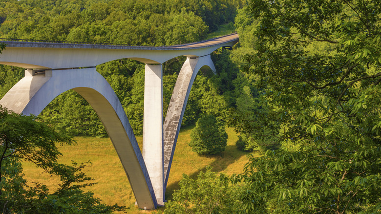
Standout stops on the Natchez Trace Parkway include the magnificent double arches of the Natchez Trace Parkway Bridge at Birdsong Hollow and the numerous Native American earth mounds. Among them are the Pharr and Bynaum Mounds that date back almost 2,000 years. At milepost 10.3, you'll find the monumental Emerald Mounds towering 60 feet above and sprawling across eight acres. If you're feeling energetic, you can park up and hike the Natchez Trace National Scenic Trail, which shadows the parkway's course and provides abundant trailhead access.
Historic Columbia River Highway
Just 20 minutes or so from downtown Portland is the start of a 70-mile stretch of road known as the Historic Columbia River Highway. This road runs along the Oregon-Washington border and tracks the Columbia River from Troutdale to The Dalles, with two drivable sections separated by a stretch where you follow Interstate 84. It was constructed in the early part of the 20th century and is actually the oldest scenic route in the United States. By 1998, it had achieved federal recognition as an All-American Road, which acknowledges its exceptional scenery and historic significance.
As it's one of the shorter drives on this list, most travelers complete it in a matter of hours. However, you can stretch it out by adding in any of the many viewpoints or hiking stops. However long you take, you can access the drive at any time of the year, with wildflower blooms and thunderous waterfalls in spring and fiery foliage in fall being the best seasons for photo opportunities.
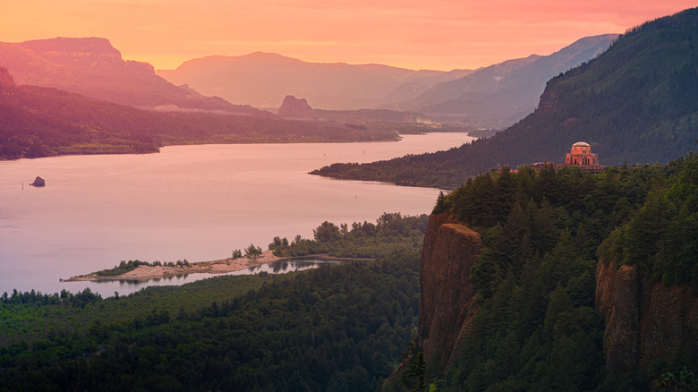
Photographers will particularly love the western section. This is where you'll find Multnomah Falls, the Pacific Northwest's most-visited natural attraction, plunging from 620 feet above. Latourell Falls is another favorite, while more unforgettable photo opportunities can be found on a drive up to Vista House at Crown Point, which sits high above the Columbia River. Rowena Crest viewpoint on the eastern portion is another worthwhile stop, but it is advisable to do the drive early in the morning, preferably on weekdays, to avoid the heaviest congestion.
Cascade Loop Scenic Byway
For some of the Northwest's prettiest mountains, lakes, and island views, the Cascade Loop Scenic Byway is a drive well worthy of your consideration. This 440-mile circuit passes through some of the most dramatic scenery in Washington State, starting at Everett, just north of Seattle. As it's a fairly short route, you can drive it in a day. However, to take in all the sights, it's ideally experienced in five days or more. The loop is completely paved and well-maintained, but plan for late spring to early fall. This is necessary because the North Cascades Highway section of the circuit closes under the weight of heavy snowfall every year.
You'll start your leisurely five-day itinerary hugging the Skykomish River's course and ascending through Stevens Pass Greenway, where you'll find imposing jagged peaks dominating the horizon. There's a popular ski resort here if you fancy parking up and hitting the slopes, while you can also enjoy spectacular waterfall diversions at Deception and Alpine Falls. Day two threads through a succession of mountain-carved valleys at Wenatchee, Lake Chelan (one of America's deepest), and Methow, home to the town of Winthrop, which is famed for its 300 days of annual sunshine.
By day three, you're pushing into terrain dominated by snow-mantled summits exceeding 9,000 feet in the North Cascades National Park. There are more opportunities to get energetic in this area with hiking trails leading to secluded glacier-fed turquoise lakes. Day four sees the terrain transition to pastoral rolling farmland before reaching Fidalgo Island and Anacortes, where there is excellent whale-watching of various species year-round. On day five, you'll return to Everett along Whidbey Scenic Isle Way, passing through Oak Harbor and the historic Coupeville — Washington's second-oldest settlement.
North Shore Scenic Drive
Unfurling alongside the mighty Lake Superior is an idyllic all-American adventure known as the North Shore Scenic Drive. At 154 miles, it's relatively short, but it offers travelers continuous views of those famed waters framed by forested ridges and rugged coastline. It's another stunning All-American Road drive, and access is usually year-round — although it's still best to check in winter. Whether you choose rust-red maples in fall, snow-lit horizons in winter, or endless fresh lake breezes in summer, you'll find it to be a smooth and just about carefree cruise, with picnic tables, rest spots, scenic viewpoints, and camping facilities throughout, all contributing to the journey's ease.
Small towns like Duluth, Two Harbors, and Grand Marais are peppered along the route. They are troves of quirky shops, cafes, and galleries, and offer easy access to places to eat, sleep, or just stretch your legs. The journey begins at Duluth Canal Park with its famous Aerial Lift Bridge. This is the perfect spot if your idea of fun is ship watching. True enthusiasts will also find the fascinating Lake Superior Maritime Visitor Center here, while everyone can enjoy lakeside walks.
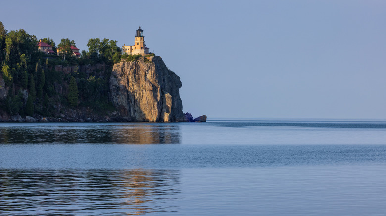
Further along the route, you'll find Split Rock Lighthouse standing proudly atop a sheer, rugged cliff and overlooking the vast expanse of the deep blue lake. You can take a guided tour of this historic attraction or simply admire it from below before proceeding onward to other photogenic locations, like Gooseberry Falls State Park, with its accessible trails and multi-tiered waterfalls, or Palisade Head, where sheer cliffs drop down into the blue expanse. At the northern end of the road, you'll find the Grand Portage State Park with its accessible trails leading to the tallest waterfall in the state — the aptly named High Falls.
Methodology

We turned to trusted travel sources such as Lonely Planet, National Geographic, and Samantha Brown's travel guides to find some of the most scenic drives across the United States. We evaluated each one against criteria including road conditions, accessibility, and stopping points to ensure the drives are not only easy to travel but also memorable to experience. We didn't include some more famous routes that have unavoidable, tricky sections that might put off less experienced drivers, though there may still be some hairpin turns and high altitude to deal with on some of the ones we did include. So, drive slowly and carefully when encountering these sections, and don't let the stunning views distract you too much.